Six months passed since my first snowy venture up Big Pine Creek. What I saw back then only whetted my appetite to explore the area more. With a record breaking snowpack brought by the last winter, timing for the 4th of July weekend was about right to still enjoy some snow in the High Sierra. After injuring my toenails while paying tennis two weeks earlier, I scaled my plans down to two overnight trips. One up North Fork of Big Pine Creek and another up to Bishop Pass.
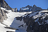
Big Pine Creek Road and Trailhead give access to the creek's North and South Forks leading up to the Palisades, rugged peaks ranging from 13,500 to 14,248 in elevation, and small glaciers below them. The lakes below the glaciers have a turquoise color from the glacier silt suspended in the water.
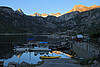
I love the eastern Sierra. What I could do without is the long, long drive to get there from the San Francisco Bay area. At times I dream of moving to Mammoth Lakes, and spending all the time skiing and photographing the Eastern Sierra and the nearby deserts. As the Tioga Pass was open, I crossed the Sierra in Yosemite, passed Mammoth Lakes, and drove down to Bishop to pick up my backcountry permits. I found I could only get the first permit, and would have to come back two days later for the next. The temperature in Bishop was pushing 100F. It was a relief to leave Bishop behind, and drive up to the Four Jeffrey campground. At 8,100 ft, it was much cooler there, and it would give me an opportunity to acclimate having come from the zero elevation of the Bay Area. After setting up my tent, I drove still higher up to the nearby Lake Sabrina. Another fork of the road lead me to South Lake, which was to be my trailhead three days later. Mosquitos there were vicious, a sign of the days to come.


|

|

|

|

|

|
| Tioga Pass Road | Highway 395 | Lake Sabrina scenery | Kayaks | Lone boat | Lone boat |

|

|

|

|

|

|
| Lake Sabrina | Lake Sabrina | South Lake boat landing | South Lake scenery | Last sunlight | Four Jeffrey Campground |
I got up at an ungodly hour to catch a sunrise at Lake Sabrina. I caught some alpenglow on peaks behind the lake, and shortly after the sunrise returned to the campground to pack up the camp, and get ready for the backpacking trip ahead.


|

|

|

|

|

|
| Road to Lake Sabrina at dawn | Alpenglow | Sunrise | Kayaks and boats | Lake Sabrina reflection | |
|

|

|

|

|

|
| Sabrina Boat Landing | Reflection | Rear view mirror view | Four Jeffrey Campground | Mt. Tom |
After going back down to Bishop, and a few miles south to Big Pine, I drove up the Big Pine Creek Road to the trailhead. The trail follows south facing slopes, and I was happy for my relatively early start. This would be a tough, hot slog in the afternoon sun.
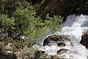
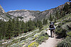
Shortly after leaving the trailhead at 7,600ft , I caught up with a family of backpackers. They were originally from Ukraine, and also into photography. We chatted for a while until I finally left them behind. Some ways up, the trail passes a waterfall, and follows the creek Trees provided some shade there, but soon enough I missed the dry slopes when mosquitos started swarming all around me. I recognized places I remembered from my winter hike. Compared to that hike which seemed like a sprint up the valley, I made slow progress this time being burdened by a heavy pack. I finally reached a point where I had turned around six months earlier. Shortly after, the trail forks. One leg goes up to Black Lake. The other continues up to First Lake, and Second Lake where I planned to camp.


|

|
|

|

|

|
| Trail | South Fork valley | Backpacker | Tree and a waterfall | Lonely tree | Entering John Muir Wilderness |

|
|

|

|

|

|
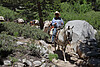
| Big Pine Creek | Pack animal leader | Cascade | Climbers | First Lake |
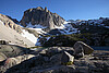
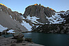
The midday sun was beating down as I passed First Lake, and I was happy to finally reach the Second Lake. The lake was quite a sight with its turquoise water fed from the Palisade Glacier. As I looked for a good spot to take a photograph, fellow backpackers taking a break warned me there was more to the view - they called it a bikini contest. As I came around the corner, I recognized a young lady that left from the trailhead shortly before me. She camped on a prominent spot above the lake. She apologized for being in my shot. I am not sure she realized she made the shot...
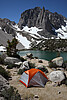
I found a great campsite (10,100ft) with a view nearby, and after replenishing my water supply down at the lake, I spent the rest of the afternoon trying to stay out of the sun, and rock hopping near my camp with the view of the lake, Temple Craig, and the Palisades above.


|

|

|

|

|

|
| Bikini contest | Lake level | Site with a view | Craggy tree | ||

|
|

|

|

|

|
| Sun | Palisade Glacier | Balancing rock | Copper Spur and Temple Crag | Yours truly | |

|

| ||||
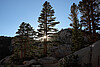
The sun finally started going down in the sky. As is often the case in the Eastern Sierra, it set behind the mountains before its light became very colorful. Even without a colorful atmosphere, the glacier positioned rocks and weathered trees provided plenty of photo opportunities. The situation reverses in the morning when the first sun rays illuminate the eastern side of the mountains. I had something to look forward to.


|
|
|

|

|

|
| Slit | Tree brothers | Boulders and Temple Crag | Second Lake shores | A tree and a moonrise | |

|

|

|

|

|
|
| Second Lake | A tree and the moon | Last sun rays |
An early bird catches a fly. It was the second consecutive morning of getting up before the sunrise to catch the first sun rays, and it was definitely worth it. Temple Crag was illuminated from a side, letting its structure stand out, and the rest of the mountains and Second Lake complemented the scenery.


|

|

|

|

|

|
| Alpenglow on Temple Crag and the Palisades | Red light | A tree and Temple Crag | Light and shadows | ||

|

|

| |||
| Light changing to yellow | A tree and Temple Crag |
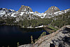
After a small breakfast while enjoying views from my campsite, I continued along the trail that winds in the trees above Second Lake. I sidetracked to take a few clear shots of the lake from cliffs above it, and continued up past Third Lake. The trail rose steeply and soon enough bigger patches of snow appeared. I was assaulted by mosquitoes when I took a break after crossing a stream. I made a short detour to Fifth Lake and appreciated an amazing view of Two Eagle Peak, Mt. Robinson, and even North Palisade out in the distance above it all.
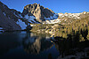
Backtracking a bit, I continued now through lots of snow to Fourth Lake, along its shores and above it to an overlook at 10,850 ft with a magnificent view of the entire western skyline. Summit Lake was only a short walk and some ways up from there and its still water made for great reflections.

I retraced my steps, first back to the camp at Second Lake. A few clouds starting forming above the mountain tops. After packing up, I started a long descent to the trailhead, occasionally stopping to take a few pictures. I could not dawdle too much since my next backcountry permit was waiting to be picked up in Bishop.

 or,
if you prefer, sign an entry in the
guest book.
or,
if you prefer, sign an entry in the
guest book.